Badlands Leading Lines

The Badlands
Badlands is a geologic term. They are characterized by soft sedimentary rocks that erode easily. Besides South Dakota, badlands are found in Wyoming, Utah, North Dakota, Colorado, Arizona and Nebraska.
Deposition and then erosion created the formations in South Dakota’s Badlands National Park. Rocks were gradually built up in layers through deposition. Shallow inland seas, rivers and wind created this geologic “layer cake” starting 75 and ending 28 million years ago,
The rocks then gradually wore away through erosion. Roughly half a million years ago, the Cheyenne River and White River began flowing through the area. Running water cut through the layers creating the narrow channels, canyons, and rugged peaks of the Badlands.
Erosion is still occurring. The rocks in the Badlands lose one inch per year. That’s pretty fast compared to the nearby Black Hills where it takes 10,000 years to erode one inch of granite. Visit soon; we only have a half million years before the Badlands are completely eroded away!
Lots of rocks
The Badlands’ formations contain sandstones, siltstones, mudstones, claystones, limestones, volcanic ash, and shale. The formations start with the oldest layer at the bottom and then move upwards in space and time. The youngest layer is on top of the formations.
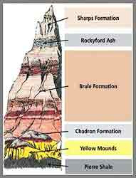
The bottommost layer is Pierre Shale deposited 75-69 million years ago. It comes from a shallow inland sea known as the Western Interior Seaway.
After the Seaway drained, the shale weathered into soil. That soil fossilized and became the Yellow Mounds.
Light gray claystone, the Chadron Formation, was deposited about 37-34 million years ago from an ancient floodplain.
The pale pink Brule Formation, deposited 34-30 million years ago, is next. It’s a mixture of claystones, mudstones, siltstones, freshwater carbonates, volcanic ash and sandstone.
At the top is the Sharps Formation, deposited 30-28 million years old. The base of the Sharps Formation is Rockyford volcanic ash. The upper layers are siltstone deposited by wind and water.
Leading lines
Photographs are two dimensional. Lacking depth, you need something to draw the eye through the scene. One method to direct the eye is leading lines.
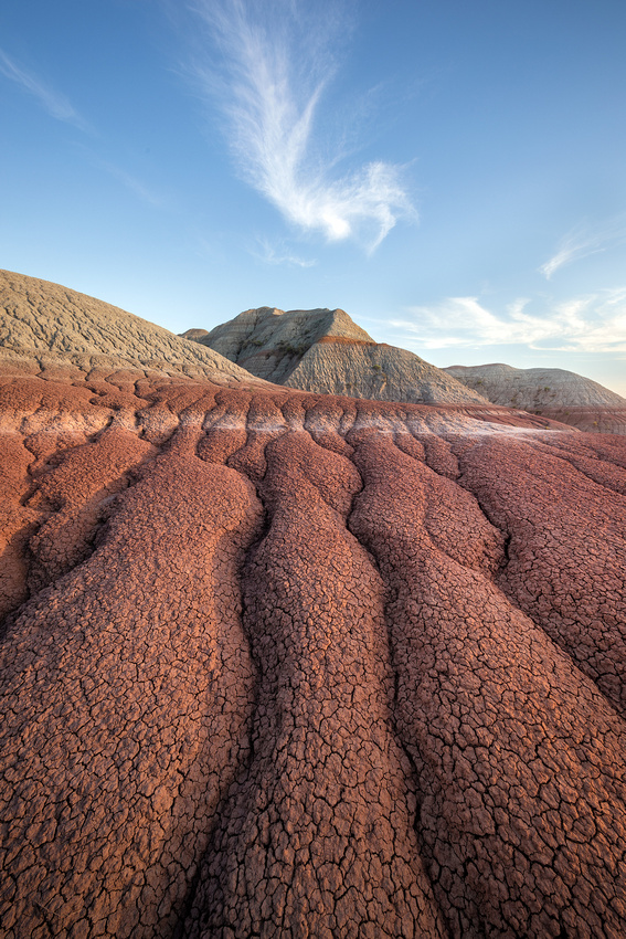
The arid, clay rich soil dries into popcorn shapes and gives rise to photogenic erosion channels. The channels can become foreground leading lines to the formations and layers in the distance.
While wandering off the beaten path on my first visit to the Badlands earlier this month, this particular collection of channels seemed to line up well with the peak behind it. I waited about 20 minutes for the distinctive cloud to drift over the peak.
After that, I carefully moved on to other compositions as the sun started to set. Why carefully? That’s for another Friday Photo story about meeting a rattlesnake.
Thanks for looking,
Chuck Derus