The Gunflint Trail

The Gunflint Trail, Cook County Highway 12, is a two-lane paved highway. The road begins in the small harbor town of Grand Marais, Minnesota.
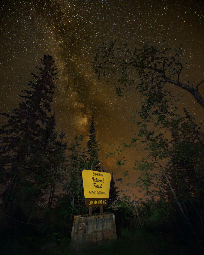
It then winds northwest 57 miles through the wilderness, ending four miles south of the U.S./Canada border at Trail’s End Campground. Along the way are more than two dozen resorts and canoe outfitters.
The Gunflint Trail climbs 600 feet in the first few miles to Pincushion Mountain Overlook, a parking area with spectacular 180° views of Lake Superior. That’s where fellow photographer and friend Jon Christofersen and I ended our August night photography trip.
Framing
Every time we use a camera, we create a frame. But creating a frame within that frame can contribute to striking and powerful images. Framing can lead the viewer’s eye, imbuing balance and creating visual flow through the image.
The Shot
We were running out of time. Our weather apps and our eyes told us a thick layer of Canadian wildfire smoke was rapidly approaching.
After several unsuccessful compositions, I moved to the opposite end of the parking lot and looked around. The trees, aided by distortion from my wide-angle lens, seemed to nicely frame the Milky Way. I hurriedly set up my camera on the tripod and checked my composition.
I barely had enough time to recompose and take one additional photograph before the smoke moved in and totally obscured the Milky Way.
I hope you all have a wonderful Thanksgiving holiday.
Thanks for looking,
Chuck Derus
Comments
|
January
February
March
April
May
June
(2)
July (2)
(4)
August (4)
(4)
September (4)
(4)
October (4)
(4)
November (4)
(5)
December (5)
|
(4)
January (4)
(4)
February (4)
(4)
March (4)
(4)
April (4)
(3)
May (3)
(4)
June (4)
(5)
July (5)
(3)
August (3)
(4)
September (4)
(4)
October (4)
(4)
November (4)
(4)
December (4)
|
(4)
January (4)
(4)
February (4)
(2)
March (2)
(4)
April (4)
(3)
May (3)
(4)
June (4)
(1)
July (1)
(4)
August (4)
(5)
September (5)
(3)
October (3)
(4)
November (4)
(3)
December (3)
|
(4)
January (4)
(4)
February (4)
(4)
March (4)
(4)
April (4)
(4)
May (4)
(3)
June (3)
(4)
July (4)
(4)
August (4)
(5)
September (5)
(4)
October (4)
(2)
November (2)
(4)
December (4)
|
(4)
January (4)
(3)
February (3)
(5)
March (5)
(3)
April (3)
(2)
May (2)
June
July
August
September
October
November
December
|