Welcome to the landscape photography blog by Chuck Derus. Thanks for looking and for your comments!
The Frozen Desert

Hot comes to mind when you hear the word desert. But imagine a bizarre landscape of sand dunes, mountains, and extremely cold temperatures.
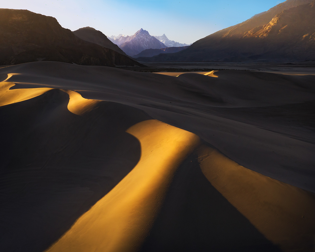
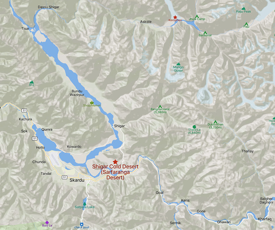
Welcome to a desert in Pakistan where biting cold dominates the landscape. At 7,500 feet above sea level, you’re in the Sarfaranga Desert, also called the Sarfaranga Cold Desert.
Located in the Shigar Valley near the town of Skardu, this desert displays immense diversity. The Indus River flows nearby. Towering mountains encircle the desert, with their greyish-black hues providing a dramatic backdrop that contrasts with endless golden sand fields. Sinuous, sensual dune shapes are everywhere. Ever-present strong winds create a magical atmosphere of dust and sand in the air.
Flying into Skardu in the Shigar Valley gave us our first taste of the sheer mountains in the area. You don’t gradually descend into the Skardu airport; you corkscrew your way down to the ground.
Our group leader somehow talked his way into a cockpit jump seat ride to Skardu. Arriving over Skardu, the pilot put the plane into a tight spiraling descent to the airfield, with the cockpit warning system blaring “Terrain!” repeatedly until the plane landed.
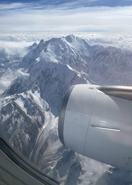
The view out my window near Skardu. Our cruising altitude isn’t much higher than the mountains!
The best time to visit the Sarfaranga Desert is from June to September when temperatures range between 46 and 75 degrees. The temperature can drop as low as 1 degree above zero between October and May. Luckily, we had a mild afternoon day in the 30s when I was there.
The Shot
On the afternoon of November 4, our photography group turned off the main road from Skardu and into the Sarfaranga Desert. Because the mountains are so high, sunset was going to occur at least an hour early when the sun dipped below the mountains.
I launched my drone with a wide-angle lens and pulled out my big camera with a telephoto lens. It turned out that one camera couldn’t capture the magic of what my eye was seeing.
I used a photo from each camera to create a focal length blend. Blending the wide-angle drone photo of the foreground dunes with the distant telephoto view of the mountains allows viewers “to be there” and experience what I saw.
Thanks for looking,
Chuck Derus
The Hawk Wind
 “By the shores of old Lake Michigan / Where the Hawk Wind blows so cold..."
The first line of Steve Goodman's song, "A Dying Cub Fan's Last Request"
Five generations of loyal fans endured 108 years of seemingly endless exasperation. The 2016 World Series Champion Chicago Cubs finally snapped a losing streak dating back to 1908. During that void, resilient Chicagoans reassured each other that “Anyone can have a bad century.”
Steve Goodman’s classic song captured the angst of loyal Cub fans during those dark decades. While most of the lyrics make sense to me, I’ve always wondered about the Hawk Wind reference.
If you’ve been to Wrigley Field or anywhere near the Chicago lakefront, you know how a cold wind off the lake can transform a pleasant outing into an exercise in cold weather survival. But what’s this Hawk Wind reference?
Describing Chicago's wind as “The Hawk” or “Hawk Wind” or “Hawkins” is attributable to its popularity in African American vernacular English. The first mention is in "Weather-Lore," by J. H. Evans, published in the 1896 Southern Workman.
The article suggests that the use of “Hawkins is coming,” meaning cold weather is coming, was passed down from the "dark ages of [African American] slavery." The article further states “…when our fore parents were driven by their owners late, and early, they were taught nothing but hard work, therefore they were not able to read or write. But nature taught them many signs regarding the weather.”
Evans documents many examples of cold weather signs including “...If turkeys roost high in a tree, it's a sign of cold weather. You will hear the old folks say, ‘Look out children, Hawkins is coming.’”
The Baltimore Sun ran a series of columns in 1934 examining the origin of the phrase. According to the newspaper, "Hawkins is coming" describes a cold, winter wind.
The Chicago Defender first used the term on October 20, 1936. It wrote "And these cold mornings are on us - in other words 'Hawkins' has got us."
In 1967, Chicago native Lou Rawls wrote this opening lyric to his song Dead End Street.
“I was born in a city they called the 'Windy City'
And they call it the 'Windy City' because of the 'Hawk.' All mighty Hawk
Talking about Mr. Wind kind of mean around wintertime…”
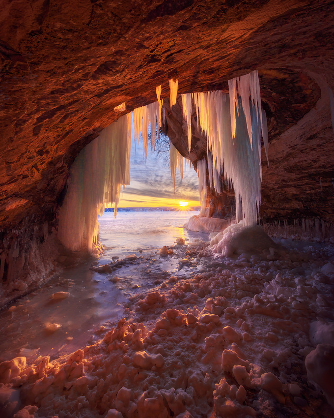
The Shot
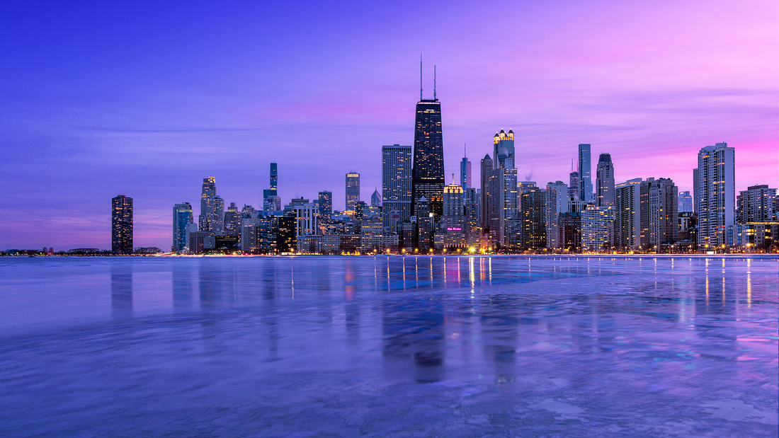
It’s been cold enough in Chicago recently for some serious ice to form on the Lake Michigan Shore. Last Sunday afternoon I joined fellow photographers Scott Fuller and John Tarsha for a trip to the city. We settled on North Avenue Beach as the location to explore with our cameras.
Multiple ice-covered objects were on the beach and near the shore. But it was the skyline that interested me the most. The ice in the water left an indelible impression of cold as I looked through the viewfinder.
I set up my camera to look south at the skyline. And then I waited for sunset and the blue hour. The weather up to that point had been cold but tolerable with a light breeze.
Color started to appear in the clouds as the sun neared the horizon. But the approaching sunset also brought The Hawk. The now biting cold wind convinced me to head for the warmth and shelter of Scott’s car instead of lingering.
Thanks for looking,
Chuck Derus
Growing Up with Winter
“Growing up in a place that has winter, you learn to avoid self-pity. Winter is not a personal experience, everybody else is just as cold as you, so you shouldn't complain about it too much. You learn this as a kid, coming home crying from the cold, and Mother looks down and says, 'It's only a little frostbite. You're okay.' And thus, you learn to be okay. What's done is done. Get over it. Drink your coffee. It's not the best you'll ever get but it's good enough.” Garrison Keillor of Prairie Home Companion
A Rude Awakening
My annoying iPhone alarm jarred me from a deep sleep. I groggily looked around a dark, unfamiliar room. Where was I? And why was I getting up at 5am?
And then I remembered. It was my hotel room in Munising, Michigan. Today was my second day to head out and photograph the icy Lake Superior shoreline in subzero, windy conditions.
For a moment, I was tempted to pull the warm comforter over my head and go back to sleep. It was supposed to be even colder today. And it had taken me hours to warm up yesterday.
But wait a minute. I’m from Minnesota and going out on a cold day is what you do! So, I dressed in layers, ate a few mini donuts for breakfast, and headed to the snowmobile parking area.
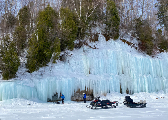
Along with several other photographers that cold March 4, 2022, morning, we were transported by snowmobile across the frozen bay to Grand Island.
It looked promising. Unlike the day before, there was an opening in the overcast to the east. Colorful clouds or a star around the sun as it peaked above the horizon were both possible. And thanks to scouting the area the day before, we knew the location of several sea caves offering interesting compositions.
The Shot
I wedged myself as far back in a sea cave as I could go. I locked down my camera on the tripod after tweaking my composition and waited for the sunrise.
I wasn’t disappointed! As the sun cleared the horizon, red-yellow sunlight flooded the cave, bouncing off the ice and sandstone further intensifying the already warm light. I pressed the shutter just as the sun peaked over the distant shore, capturing my star around the sun.
We continued to photograph until we started to lose feeling in our fingers and toes. After that, we returned to the Falling Rock Cafe and Book Store in downtown Munising for a hot cup of coffee and breakfast.
Getting ready to leave for breakfast in town.
Thanks for looking,
Chuck Derus
Doorway to Heaven
This evocative phrase opens chapter two in Peter Zuckerman’s book, Buried in The Sky, about climbing K2. The K stands for Karakoram and the 2 for the second of 32 numbered peaks in the towering Karakoram Mountain range of Northern Pakistan.
The Karakorum is the Earth’s youngest mountain range. It was born a mere 65 million years ago at a time when the dinosaurs were facing extinction.
The Indian continental tectonic plate was speeding North at six inches a year, “a reckless pace in geologic time” according to Zuckerman. It ploughed into Eurasia wedging itself under the larger continent. The Karakorum Mountains, like Mount Everest, rose from the sea and are still rising today.
This 500-mile-long Karakoram range has the world’s largest concentration of peaks more than five miles high. It contains eighteen summits higher than 24,600 feet in elevation. Four of them are above 26,000 feet: K2, the second-highest peak on Earth at 28,251 feet, Gasherbrum I, Broad Peak, and Gasherbrum II.
Harsher than the Himalayas, the Karakoram is the most glaciated place on the planet outside of the poles. And unlike older mountain ranges, erosion has barely smoothed the jagged edges of the Karakorum.
Kara means black, and koram means gravel or rock. Central Asian traders originally applied the name Karakoram to a pass in the range. At an elevation of 18,176 feet, the Karakorum pass is the highest pass on the ancient silk road.
The pass connects Leh in Ladakh (Kashmir in Northern India) and Yarkand in the Tarim Basin (the Chinese gateway to Central Asia). Shawls, indigo, tea, corals, and muslin went North, while silk, precious metals, costumes, and jewelry went South.
Early European travelers, including William Moorcroft and George Hayward, climbed the pass in the 1820s and applied the name Karakorum to the range of mountains west of the pass.
K1 to K32
British Lieutenant Thomas Montgomerie was part of the Great Trigonometric Survey of British India that set out to measure the shape of the Earth in the 1850s. His porters labored for four days to haul a plane table, heliostat, and theodolite up Mount Haramukh in the Himalayan foothills to measure the peaks. Montgomerie was rewarded by a panoramic view of multiple spires.
Two peaks towered among the others 130 miles to the Northeast. He labeled the tallest peak K1. K stood for Karakorum and the 1 signified the first peak in his survey. He labeled the second highest peak K2. He eventually logged 32 peaks in total.
But Montgomerie’s initial visual measurements proved to be incorrect. K2 is actually taller than K1 by 2,592 feet. That makes K2 the second highest mountain on Earth and only 781 feet less tall than Mount Everest.
K1 quickly reverted to its native Balti name of Masherbrum. K2 has retained its alphanumeric moniker. But its actual name is Chogori, a Tibetan name meaning “Doorway to heaven.”
The Shot
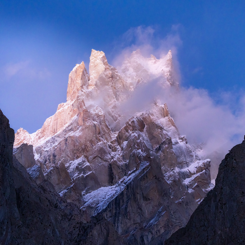
My November photography group never saw K2. It requires a seven-day trek at altitudes of up to 18,000 feet to get within visual range. However, we witnessed the majesty of Masherbrum (K1) on many occasions.
On November 3, we attempted to photograph Masherbrum at sunset. But the clouds shrouded the peak, making for poor photographs. Instead, we aimed our cameras at a pair of peaks in the distance.
The distant peak on the back upper right is called Grey Towers by the locals. The unnamed peak in the lower left is quite a bit closer and shorter. A telephoto lens compressed the apparent distance between the pair of peaks.
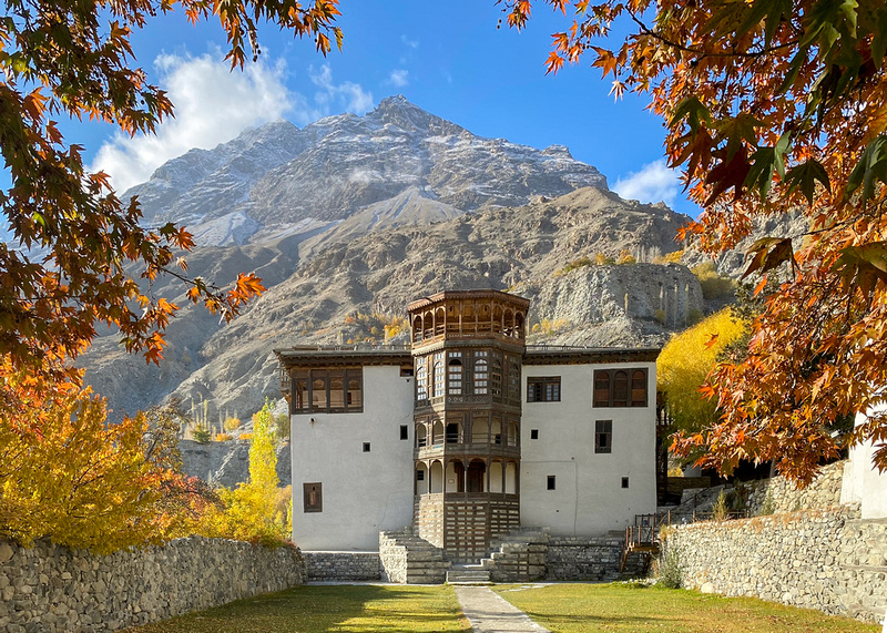
This was our last set of images for the day before heading back to our hotel room in Khaplu in the restored former royal residence of Baltistan.
Thanks for looking,
Chuck Derus
The River That Powers Civilizations
The River That Powers Civilizations
Pakistan is a country of 300 million people in an area only the size of Texas. Since time immemorial, water from the Indus River has sustained agriculture, life, and the birth of major civilizations.
The Indus was known to ancient Indians in Sanskrit as Sindhu and to Persians as Hindu. From the First Persian Empire, the name passed to the Greeks as Indós. It was then adopted as Indus by the Romans.
Interestingly, the name India is derived from Indus.
The Indus River begins humbly as a mountain spring. Fed by snowmelt, glacial meltwater, scant rain, and tributary rivers from the mountains of the Himalayas, Karakoram, and Hindu Kush, it flows almost 2,000 miles to the Arabian Sea.
The river’s course takes it from its origins in Western Tibet northwest through the disputed region of Kashmir. It then bends sharply to the left in a 17,000-foot-deep gorge after the Nanga Parbat massif (mountain). From there it flows south-by-southwest through Pakistan ending as a large delta emptying into the sea near the port city of Karachi.
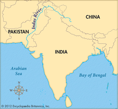
The river’s statistics are impressive. It drains an area of about 430,000 square miles. With an annual flow of 58 cubic miles of water, it ranks as one of the 50 largest rivers in the world. It supports the ecosystems of temperate forests, plains, and arid countryside.
Ancient Civilizations
The river is historically important to many cultures in the region. The Indus Valley Civilization arose there during the third millennium BCE. It was one of the largest urban human habitations in the ancient world.
In the second millennium BCE, the Punjab region was mentioned in the Rigveda hymns as Sapta Sindhu and in the Avesta religious texts as Saptha Hindu (both terms meaning "seven rivers"). Other ancient civilizations in the Indus Valley include Gandhāra and the Ror dynasty of Sauvīra.
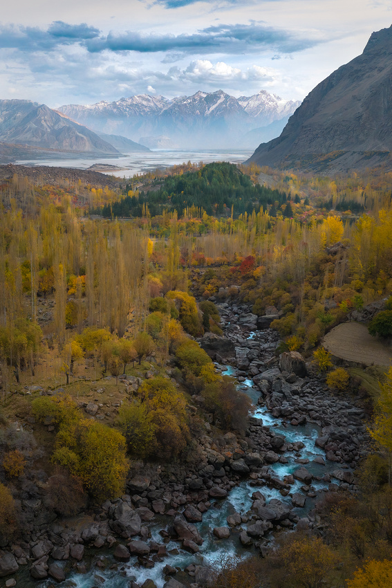
The Shot
Our group stopped several times to admire and photograph the Indus in November. The river was at its seasonal low for flow. We could only imagine what it looked like flooding its banks in the monsoon months from July to September.
The Indus River outside Skardu with rows of planted poplar trees on the right
We stopped outside the town of Kachura near Skardu to capture this small tributary winding its way to the mighty Indus in the background. I piloted my drone to several locations before settling on this composition.
Thanks for looking,
Chuck Derus