Welcome to the landscape photography blog by Chuck Derus. Thanks for looking and for your comments!
You Can't Always Get What You Want


"You Can't Always Get What You Want" Mick Jagger and Keith Richards
I wanted a sunset shot from Willis Tower. Friend Paul Teodo, his son Peter, and I decided to head to downtown Chicago’s Willis Tower (still called the Sears Tower by stubborn Chicagoans) for a sunset experience. The weather forecast suggested a good chance of a colorful sunset.
But the first stop was a favorite Mexican restaurant of Paul’s, 5 Rabanitos in the Pilsen neighborhood. After a hearty meal, it’s now my favorite as well.
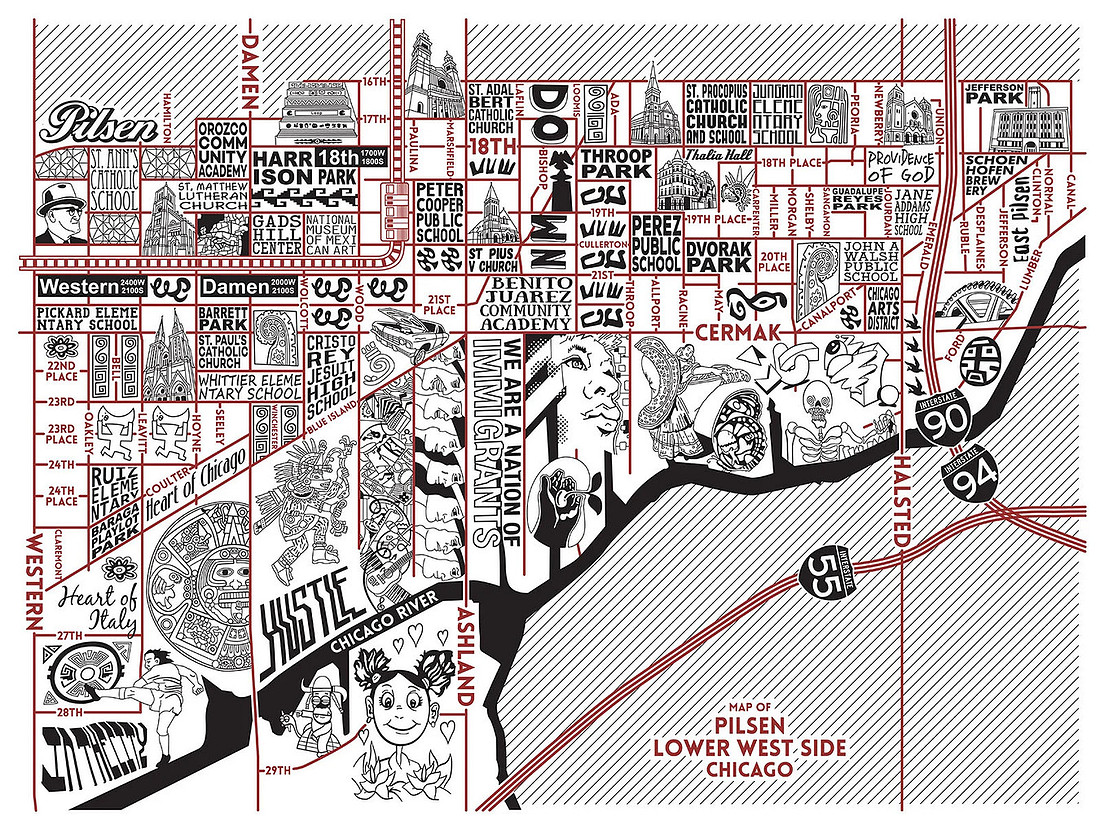
The Pilsen Neighborhood as illustrated by Chicago Neighborhood Maps — Joe Mills Illustration
Since we had time to spare, I grabbed my camera, and we started walking. Pilsen is famous for its murals painted by local artists.
We headed North towards the railroad viaducts. Wow! What a riot of colors and subjects.
The Shot
After leaving Pilsen, the sky turned gloomy. While it’s always fun to experience the city 1,353 feet above it, good photographs require interesting light and there simply wasn’t any.
While I couldn’t get what I wanted (sunset), I did get what I needed (for a Friday Photo). Enjoy the images below framed by the viaduct supports.


 Thanks for looking,
Chuck Derus Zenfolio | Chuck Derus
Travel

"Travel is fatal to prejudice, bigotry, and narrow-mindedness, and many of our people need it sorely on these accounts. Broad, wholesome, charitable views of men and things cannot be acquired by vegetating in one little corner of the earth all one's lifetime." From The Innocents Abroad by Mark Twain
Friends thought I was crazy to visit Pakistan in 2023. Surely, I was in danger, they told me. But my visit revealed the opposite.
The people of Pakistan were welcoming, and I never experienced a sense of danger. A visit to one Pakistani village in particular will never be forgotten.
Shimshal
Shimshal is a remote village in the Hunza District of the Gilgit–Baltistan region in northern Pakistan. Located just 62 miles from the Chinese border, it’s the highest settlement in the district at 10,213 feet above sea level. There are approximately 250 households with two thousand inhabitants who live there.
It’s also the name of the largest valley in Gilgit-Baltistan, encompassing almost the entire district. The Shimshal River flows through it.
Our group’s Pakistani guide, Muqeem Baig, is from the village. He is an extraordinary athlete and one of the kindest and gentlest people I have ever met.

Me, Muqeem Baig, and Jon Christofersen
Muqeem's ancestors settled in the Shimshal Valley when Shimshal was first settled in 1450. The village was isolated for centuries. Reaching the nearest village, Passu, required a trek of three days over incredibly challenging terrain.

An ancient shelter along the trek is at the bottom of the image

A serpentine part of the trek is above the car leading to a pass
After 30 generations of living at high altitude, their strength and ability to function there is legendary. Pakistan's elite trekkers and climbers come from Shimshal.
Muqeem’s father was one of the first to climb K2, the second highest mountain in the world. And if you are climbing the 28,251-foot summit of K2, the high-altitude porters on your team are from Shimshal.
The Road to Shimshal
There was no road to Shimshal until 2003. The villagers spent 18 years hand carving a one-lane, unpaved, rocky, winding, mountain road through dozens of miles of sheer cliffs. Beginning from a turnoff on the Karakoram Highway, the road winds 37-miles up a cavernously deep valley with amazing rock formations.
The mountain is so steep that the sunlight never hits parts of the valley and river thousands of feet below. Sections of the road are supported by meticulously dry-fitted rock retaining walls, assembled with great care and skill. This traditional technique allows the walls to flex slightly and drain water naturally, making them durable.
It’s just wide enough for a single car. And sometimes it is barely tall enough for a car as it occasionally cuts into precipitous cliff faces towering hundreds of feet above the road. And it winds though boulders as big as a house.
Even the bridges are interesting. Wooden suspension bridges undulate as you slowly drive across them. You must wait for them to become still before slowly easing your vehicle across. A short video of a bridge crossing is at Zenfolio | Chuck Derus | Pakistan
The three-hour drive is “exhilarating.” Check out Jon Christofersen’s video of three minutes of this nail-biting experience at Zenfolio | Chuck Derus | Pakistan Despite its terrifying appearance, there have been no fatalities in its 22-year history.
When you finally arrive in Shimshal, you are greeted by a beautiful maze of irrigation channels running between green fields of crops. Well-maintained mud and stone houses, a school, and dirt roads lined with hand-constructed rock walls are spread evenly throughout the village. Apricots harvested from the surrounding trees are commonly seen drying on rooftops.

An apricot grove in Shimshal

A view of our hotel in Shimshal
The arid landscape features high altitude meadows for grazing surrounded by mountain peaks reaching well over 22,000 feet. Glacial meltwater powers a small hydroelectric plant (sometimes).
Our Visit
The decision to visit Shimshal was at the last minute. After the excitement and fatigue of travel, we were exhausted. It was well past tourist season, and nothing was open.
Thanks to the hospitality of the villagers, they opened the only hotel in town and laid out clean sheets and four blankets. We needed those blankets as the electric power wasn’t sufficient to run space heaters, and it dropped to freezing during the night.
Despite the late hour and no restaurants, the villagers warmed up the lobby and brought in food and tea for our group.
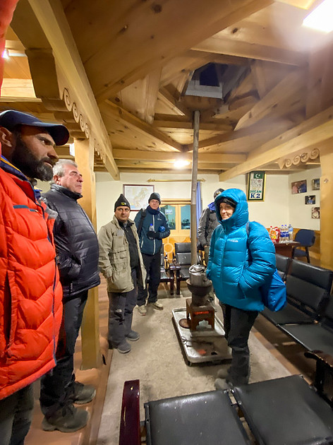
Warming up in the community room before tea
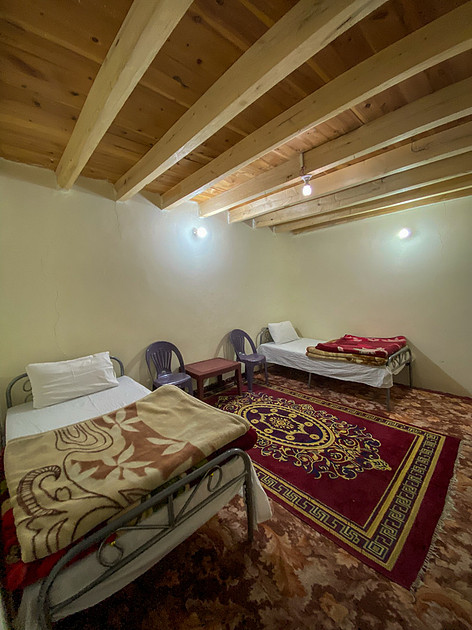
My room for the evening in Shimshal
The Shot
Today’s Friday Photo is by our tour guide Muqeem. Our intrepid group of photographers awoke well before sunrise and hiked about a mile out of the village to an overlook. But the sun didn’t cooperate, and no photographs were taken.
We returned to the village to wander around before packing. While I snapped travel photos, I couldn’t help thinking about the resilience, kindness, and generosity of our Shimshali hosts.
All of my first world problems were rendered insignificant. And whatever lingering preconceptions I had about Pakistanis vanished.
Muqeem’s iPhone image from that morning seemed to capture the beauty of his village. He graciously granted me permission to use it for my blog. Thank you, my friend.
Thanks for looking,
Chuck Derus
Best in the World

Best in the World
Have you ever dreamt about attending a world championship? A competition where attendance is free and you can meet the athletes? Your dream is coming true.
Naperville’s Nike Park is the site of the Ashley Whippet World Series Invitational on August 30 and 31. It’s a unique opportunity to see the world’s finest dogs going airborne to catch Frisbees®. The details are at World Championships
You may wonder how this sport came about. Check out my prior post on the event at Zenfolio | Chuck Derus | Disc Dog
The Shot
Last year I tested the capabilities of my new camera. The autofocus is so good that it locked on and maintained focus on a dog’s eye running full speed across the large field. And the ability to capture 30 images per second meant I had a much better chance at catching the peak of the action.
This image was my favorite from a pleasant afternoon of watching athletes who truly love their sport.
Thanks for looking,
Chuck Derus
Morton

Morton
Occasionally, tornadoes invoke powerful memories and emotions. Their impact is so powerful that a single word can evoke them. Storm chasers are already referring to the June 5th, 2025, tornado near Morton, Texas as simply “Morton.”
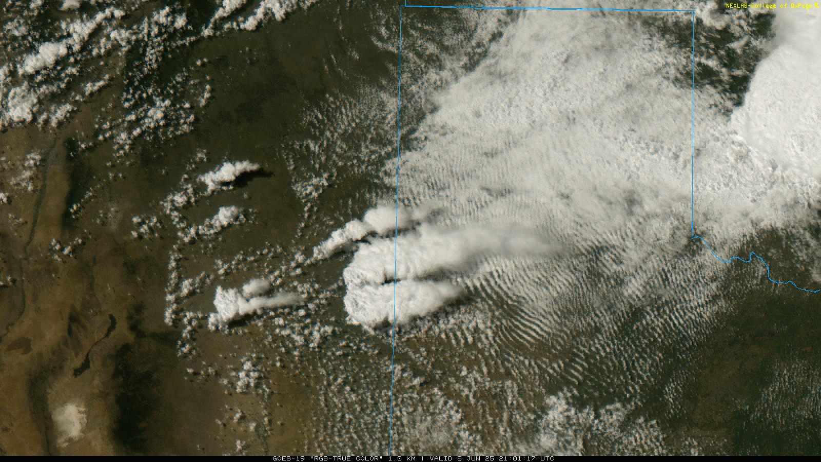
In the early afternoon of June 5th in West Texas, all the ingredients for severe weather were present. But the cap, a layer of warm air sitting 3,000 to 7,000 feet above the surface, was inhibiting severe weather. In the late afternoon, rising air finally broke the cap and an explosive storm developed.
This National Weather Service (NWS) satellite view shows how quickly the massive supercell dominated the sky. CODNEXLAB-GOES-East-local-Clovis-truecolor-22_36Z-20250605_map_noBar-20-1n-1-10.gif (1600×900)
The storm produced eight tornadoes. Our storm chasing group intercepted the storm and witnessed its first tornado near Lingo, New Mexico.

We chased the supercell as it continued, strongly rotating and producing more tornadoes as it moved East-Southeast into West Texas.
The storm was a beast with a radar signature that looked like a hurricane. The NWS radar clearly indicates the storm’s rotation with the “eye” being the location of this Friday Photo’s tornado. 4b3c186edd7e38af1df314c10310152d (632×433)
The Shot
North of Morton in Cochran County, Texas we stared dumbfounded at the sight of a massive wedge tornado kicking up huge clouds of red dust. We pulled over, jaws dropping, while we photographed this beast. The NWS determined that it was nearly a mile wide with winds of 125 mph (EF-2). It also produced hail up to 5 inches in diameter.
Today’s still image doesn’t do it justice. Check out Tom Trott’s short video clip of this monster at https://youtube.com/clip/UgkxTFJ74aCjU-qYVTcKbJrCmR4QrwH7eWvV?si=Neu1x207grQuPCL_
After this intercept, the storm was pulling away from us too rapidly to catch up for more photography. Thankfully, the city of Lubbock was largely spared. There were no fatalities and only 2 injuries associated with this event.
Missing out on the other tornadoes from this storm didn’t matter. The memories and emotions of this sighting will last a lifetime.
Thanks for looking,
Chuck Derus
High Plains

High Plains
The Wyoming landscape is diverse and dramatic. The west is dominated by the Rocky Mountains and their front range. Prairie grasslands make up the eastern half of the state and are referred to as the High Plains.
Prairie comes from the French word "prataria," meaning meadow. It was coined by French explorers and trappers during the late 18th century to describe an endless “sea of grass.”
The High Plains prairie exists because the mountains to the west cast a rain shadow. Scant rainfall favors the establishment of grasslands over forests. Drought tolerant grasses thrive there. They also recover quickly after a fire, unlike shrubs and trees.
The estimated 30-60 million bison that formerly roamed the prairie also fashioned the prairie ecosystem. These giant herbivores created an ecological symphony shaping the landscape for thousands of years.
Bison grazing patterns created a patchwork of vegetation heights and densities. Also, wallowing (rolling in the dirt) creates depressions that collect water supporting unique plant communities. Finally, bison carcasses provide critical nutrients to scavengers and the soil. They profoundly influence biodiversity.
In the 19th century, westward expansion, commercial hunting, and deliberate extermination campaigns reduced the population to fewer than 1,000 bison by 1889. This decimation was partly strategic – by eliminating bison, the U.S. government undermined the independence of Plains Indian tribes who depended on them.
The absence of bison allowed woody vegetation to encroach on grasslands, altered fire regimes, and diminished habitat diversity. In the 19th century, Wyoming settlers arrived in search of new opportunities.
The state’s climate and geography posed challenges for farming, but high prairie gave way to fields of wheat, barley, and oats.
Carpenter is one of the 176 towns and cities in Wyoming. It was formed in 1907 with a population of 15. Located on a now defunct branch of the Chicago, Burlington, and Quincy Railroad, it’s currently home to 215 people.
The Shot
On June 2, a supercell was approaching Carpenter. The wheat field in front of us was the reason for stopping there. It held promise as a foreground.
The inflow of wind into the storm was fierce, nearly blowing us over from behind. In the far distance stood a white building that would soon face the brunt of the storm.
I chose a slow shutter speed to allow the wheat to blur in the wind, conveying a sense of what we were experiencing. The eerie green glow in the sky portended the arrival of hail and copious rain.
As I stood there, I tried to imagine what it looked like 150 years ago. The foreboding sky would have been balanced by an equally impressive massive herd of bison beneath it.
Thanks for looking,
Chuck Derus