Welcome to the landscape photography blog by Chuck Derus. Thanks for looking and for your comments!
Right Time, Right Place
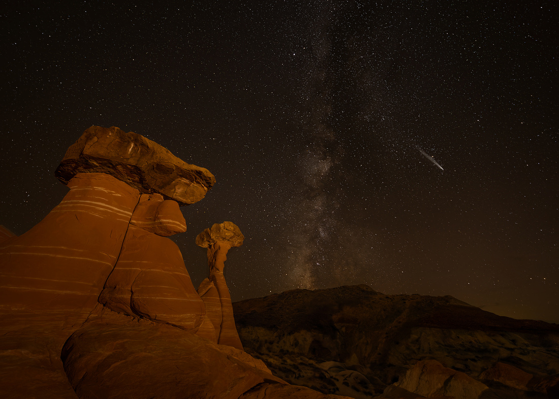

It was serendipity. The time was the early evening of October 26. The place was the Rimrocks Toadstools, a grouping of fascinating hoodoos, mushroom rocks, and rock towers near Big Water, Utah. The sky was dark and there were almost no clouds.
The reward was spotting a comet. Comet Tsuchinshan-ATLAS was making a close approach to Earth after rounding the sun earlier in the month. It was discovered in 2023 by observers at the Purple Mountain (Tsuchinshan) Observatory in China and an Asteroid Terrestrial-impact Last Alert System (ATLAS) telescope in South Africa.
This snowy dirtball is nearly 2 miles in diameter with a tail of dust and gas extending for tens of millions of miles. The last time it visited Earth was 800 centuries ago.
Tsuchinshan-ATLAS originated from the Oort Cloud. The Cloud is a spherical shell 0.03 to 3.2 light-years from the sun filled with billions of icy planetesimals. You can appreciate the size of the Oort Cloud compared to the solar system below.

From starwalk.com
Every so often, a planetesimal is dislodged towards the sun by the gravitational pulls of both passing stars and the Milky Way. As it gets closer to the sun, it heats up and develops tails of dust and gas observed by comet watchers around the world.
If a comet isn’t consumed and destroyed during its close approach to the Sun, it generally returns. Since I don’t plan on being here in the year 2824, this was going to be my only chance to see and photograph Tsuchinshan-ATLAS.
Naked eye visible comets aren’t common. I’ve been fortunate to view comets Hale-Bopp and Neowise. Witnessing a third comet in my lifetime would be a godsend.
The Shot
I belong to Photogenesis, the Naperville Camera Club. It’s called the “fun” camera club due to the camaraderie and its collaborative culture.
Scott Fuller and Steve Horne are friends from the club. Scott and I recently decided to fly to Steve’s new home in Utah and join him for a week-long Utah adventure.
It was a long flight from Chicago to St. George, Utah for Scott and me. And then we had hours of driving with Steve to reach our first photo location at the Rimrocks Hoodoos.
We photographed sunset amongst the hoodoos. Even though we were exhausted, chilly, and hungry, the allure of night photography kept us energized. We began scouting for Milky Way nightscape compositions.
Knowing the comet would be visible near Venus for a short while after sunset, I kept my eyes peeled. I was overjoyed when I spotted it and shared the news with Scott and Steve.
We frantically took images as the comet rose and gradually dimmed in the night sky. This was my favorite. After a round of high fives, we departed for a warm car, dinner, and a night’s sleep.
Thanks for looking,
Chuck Derus
Fall Leaves

"It's the first day of autumn! A time of hot chocolatey mornings, and toasty marshmallow evenings, and, best of all, leaping into leaves!" Winnie the Pooh, Pooh's Grand Adventure
What else can compare to leaping into a pile of leaves? Launching with reckless abandon, children land with wildly flailing limbs as the leaves cushion and envelop them. Squeals of excitement and laughter signal every leap.
And then it’s time to shake off the leaves and leap again. Watching them is a glorious reminder of childhood when leaves were a joy before raking became a chore.
Fortunately, adulthood brings new joys to the season. Trees adorn the landscape with rich shades of red, orange, and yellow. Nature’s fireworks create the perfect backdrop for outdoor activities and scenic drives.
The Shot
I spent several days in early October around Grand Marais, Minnesota. The fall colors were near their peak creating a perfect backdrop for photography. While en route to scout a photo location, we crested a hill, and I felt compelled to stop.
A lovely S-curve led my eye into the distance. Passing clouds created alternating bands of light and shadow. After waiting a few minutes, the light playing over the scene seemed right and I pressed the shutter.
Thanks for looking,
Chuck Derus
Mormon Row

To old time mountain men, a high mountain valley is known as a “hole.” Jackson Hole (originally called Jackson's Hole) is a valley between the Gros Ventre and Teton mountain ranges in Wyoming.
Wyoming’s population grew slowly before statehood in 1890. It remained relatively untouched and pristine until 1884 when the first white residents arrived. Most were drawn to the towns of Wilson and Jackson.
About the same time, leaders of The Church of Jesus Christ of Latter-day Saints (LDS) sent parties from the Salt Lake Valley to establish new communities. They were expanding outside of Utah, Idaho and Arizona.
Their timing was excellent. The Homestead Act of 1862, the Timber Culture Act of 1873, and the Desert Act of 1877 all encouraged settlement of the West.
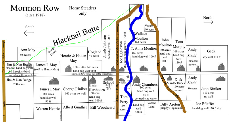
An LDS party selected a location fourteen miles north of Jackson, Wyoming in 1895. It had rich alluvial soil that was marginally better than the rock-filled dirt that covered the rest of the valley. Shelter from the wind provided by Blacktail Butte to the southwest prevented the topsoil from being blown away.
What those pioneers did was unusual. In stark contrast to typically isolated Western homesteads, the LDS homesteaders created a north-south community along a central road. They clustered their farms to share labor and community.
A church and a school were at its heart. Fields and agricultural lands were located behind each of the 27 homesteads. It was named Grovont by the U.S. Post Office after the nearby Gros Ventre River.
Mormon “line villages” such as Grovont were also known as “Mormon Rows” throughout the West. Initially the term was not flattering. Over time, it acquired a positive connotation.
The horse and wagon (sleigh in winter) remained the principal form of transportation in Jackson Hole, even after the introduction of automobiles. This kept the local cash crop of hay and oats economically viable.
Horse and hand labor built an intricate network of levees and dikes to funnel water from the nearby Gros Ventre River to their fields. Water still flows in some of those ditches today.
It was a hard life. A prolonged drought or a hailstorm could mean the difference between barely surviving and bankruptcy. The unpredictable weather caused farmers to diversify into small cattle and sheep operations.
Mormon Row initially flourished and then slowly faded over the span of nearly a century. Parcel by parcel, the National Park Service was gifted or acquired properties as leases expired.
The Shot
Often photographed, the Moulton barn with the Teton Range in the background is a symbol of Jackson Hole, Wyoming. I was looking for a different take on this icon.
I received a heartwarming birthday gift on the evening of September 25. Our leader, Don Smith, had done the planning for a night shoot at the barn. The Milky Way would be above the barn with Blacktail Butte behind it.
Arriving before sunset, I set up my tripod with my friends, Mike Loebach and Jon Christofersen. When twilight ended and the skies really became dark, we proceeded to photograph the scene and light paint the barn with a small flashlight.
I felt blessed to celebrate my special day under the stars in such a historic location.
Thanks for looking,
Chuck Derus
Like a Movie Scene
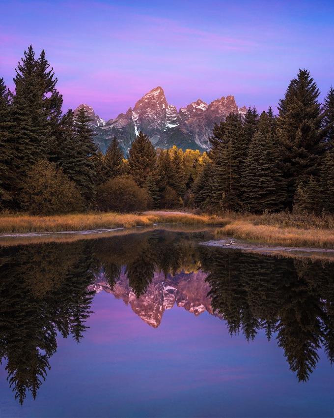
Schwabacher Landing is a photographer’s favorite. It’s one of the most popular locations in Grand Tetons National Park near Jackson, Wyoming.
The Landing offers a full, unobstructed view of the jagged, snow-capped Tetons framed by spruce and cottonwood trees. If you arrive before dawn, you can marvel at the glorious sunrise colors playing onto the glowing majestic peaks mirrored in the placid waters of the Snake River at your feet.
The location is named after a family of German immigrant settlers. The Schwabachers arrived in the late 1800s and established a homestead in the area. Beaver dams altered the course of the nearby Snake River creating a tranquil landing.
This boat landing provided vital river access. It allowed fur trappers and traders a means of entry to the remote wilderness and abundant wildlife of the Teton Range.
Over time, the fur trade waned, and Schwabacher Landing transitioned into a homestead and ranching area. Today, it is celebrated for its natural beauty, attracting photographers, nature enthusiasts, and wildlife observers.
It remains one of only four locations in the park where the Snake River can be easily accessed by fishermen, canoeists and rafters. Moose, pronghorn, mule deer, and bald eagles are commonly seen in the immediate vicinity of the landing.
Privately owned tour companies provide guided fishing and rafting trips commencing from the landing. The immediate area is also a popular spot for wedding parties. Above the landing, along the main highway, there are additional vistas of the Teton Range.
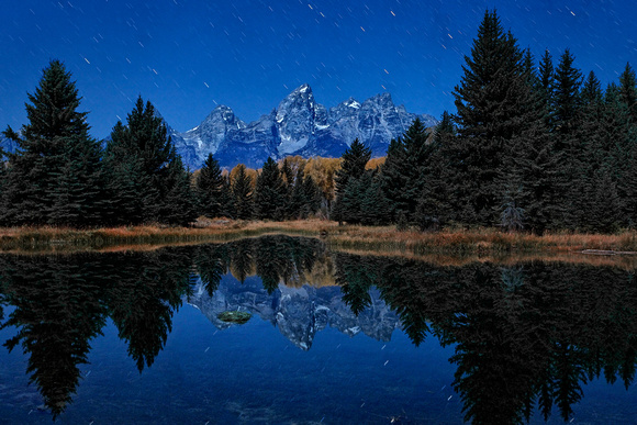
The 2010 Shot
I was privileged to first witness a sunrise at Schwabacher Landing back in 2010. I had never heard of it, but the workshop leader said it was a remarkable, hidden gem.
Out of the ten photographers on that 2010 workshop, only friend and fellow photographer Jon Christofersen and I joined our leader for a last morning of photography at Schwabacher. The rest were too exhausted and slept in.
After a short walk, we arrived to find a non-photographer sitting in a folding chair waiting to enjoy the sunrise. Jon and I set up our tripods in the tiny landing space and composed our shots. A little later, another photographer arrived, and we weaved our tripod legs together to make room for him.
The sky was severely clear (boring) that morning, so my favorite image was taken in the blue hour and featured star trails.
The Shot from September 23, 2024
When I returned to Schwabacher Landing with friends Jon Christofersen and Mike Loebach last month, we were again the first to arrive. After that, we noticed some differences.
The Landing had been cleared with room for dozens of photographers. And as dawn approached, the space was filled with camera buffs.
After taking this Friday’s Photo, we packed up and walked back to the parking lot. There must have been a hundred photographers lined up along the Snake with an equal number of tourists with camera phones enjoying the show. How times have changed.
Thanks for looking,
Chuck Derus
Country Roads
Country roads, take me home
To the place I belong
West Virginia, Mountain Momma
Take me home, country roads
John Denver, from “Take Me Home, Country Roads”
Country Roads
Childhood memories run deep. Growing up in Minneapolis, my family often headed north to explore the Arrowhead region of Minnesota. I vividly remember taking the back roads, especially in a time when President Eisenhauer’s dream of an interstate highway system was just beginning to be realized.
The further north you traveled, the more rustic it became. Grand Marais, near the Canadian border on Lake Superior, was a sleepy little town. From there, you could drive into Minnesota’s wilderness on the Gunflint Trail, a dirt road.
John Denver’s 1971 hit, Take Me Home, Country Roads, is now one of the four official state anthems of West Virginia. But the inspiration for the song had nothing to do with West Virginia.
The inspiration struck while songwriters Taffy Nivert and Bill Danoff were driving along Clopper Road in Montgomery County, Maryland. Danoff stated, "I just started thinking, country roads, I started thinking of me growing up in western New England and going on all these small roads. It didn't have anything to do with Maryland or anyplace."
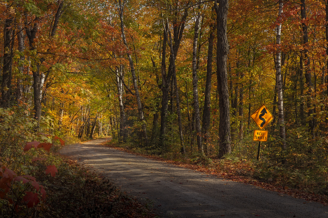
The Shot
Two weeks ago, I found myself on the Honeymoon Trail Road in the back country near Tofte, Minnesota. Suddenly, I was flooded with memories of my childhood vacations in the north woods. The country road had taken me home.
When our photography group saw the road curving nicely to the right and out of sight, we stopped for a picture. The road sign seemed to be the perfect counterpoint to the brilliant distant tunnel in the leaves where the road disappeared.
As with most rural signs, it had a few bullet holes. Actually, twenty-four bullet holes and two shotgun hits.

After taking this image, I wandered up and down the road in search of a better composition. After about an hour, we realized that the first image was the best and we piled back into the car seeking other compositions.
Thanks for looking,
Chuck Derus