Mormon Row


To old time mountain men, a high mountain valley is known as a “hole.” Jackson Hole (originally called Jackson's Hole) is a valley between the Gros Ventre and Teton mountain ranges in Wyoming.
Wyoming’s population grew slowly before statehood in 1890. It remained relatively untouched and pristine until 1884 when the first white residents arrived. Most were drawn to the towns of Wilson and Jackson.
About the same time, leaders of The Church of Jesus Christ of Latter-day Saints (LDS) sent parties from the Salt Lake Valley to establish new communities. They were expanding outside of Utah, Idaho and Arizona.
Their timing was excellent. The Homestead Act of 1862, the Timber Culture Act of 1873, and the Desert Act of 1877 all encouraged settlement of the West.
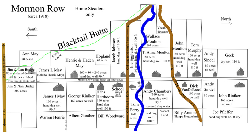
An LDS party selected a location fourteen miles north of Jackson, Wyoming in 1895. It had rich alluvial soil that was marginally better than the rock-filled dirt that covered the rest of the valley. Shelter from the wind provided by Blacktail Butte to the southwest prevented the topsoil from being blown away.
What those pioneers did was unusual. In stark contrast to typically isolated Western homesteads, the LDS homesteaders created a north-south community along a central road. They clustered their farms to share labor and community.
A church and a school were at its heart. Fields and agricultural lands were located behind each of the 27 homesteads. It was named Grovont by the U.S. Post Office after the nearby Gros Ventre River.
Mormon “line villages” such as Grovont were also known as “Mormon Rows” throughout the West. Initially the term was not flattering. Over time, it acquired a positive connotation.


The horse and wagon (sleigh in winter) remained the principal form of transportation in Jackson Hole, even after the introduction of automobiles. This kept the local cash crop of hay and oats economically viable.
Horse and hand labor built an intricate network of levees and dikes to funnel water from the nearby Gros Ventre River to their fields. Water still flows in some of those ditches today.
It was a hard life. A prolonged drought or a hailstorm could mean the difference between barely surviving and bankruptcy. The unpredictable weather caused farmers to diversify into small cattle and sheep operations.
Mormon Row initially flourished and then slowly faded over the span of nearly a century. Parcel by parcel, the National Park Service was gifted or acquired properties as leases expired.
The Shot
Often photographed, the Moulton barn with the Teton Range in the background is a symbol of Jackson Hole, Wyoming. I was looking for a different take on this icon.
I received a heartwarming birthday gift on the evening of September 25. Our leader, Don Smith, had done the planning for a night shoot at the barn. The Milky Way would be above the barn with Blacktail Butte behind it.
Arriving before sunset, I set up my tripod with my friends, Mike Loebach and Jon Christofersen. When twilight ended and the skies really became dark, we proceeded to photograph the scene and light paint the barn with a small flashlight.
I felt blessed to celebrate my special day under the stars in such a historic location.
Thanks for looking,
Chuck Derus