Welcome to the landscape photography blog by Chuck Derus. Thanks for looking and for your comments!
Battered But Not Broken

The South American Lenga tree is a survivor. It’s a deciduous tree or shrub native to the southern Andes range. It grows in areas with low temperatures down to −22 °F and abundant snow.
The northern half of its distribution is only in the Andes. It’s found at sea level in its southernmost natural environment. It can even survive in Tierra del Fuego, the southern tip of the New World.
The Lenga can reach heights of up to 100 feet with a trunk diameter of 5 feet In more northern regions, it grows only at heights above 3300 feet in the form of a shrub.
The dark green elliptic-shaped leaves are dark green and turn to yellow and reddish tones in autumn. The fruit is a small nut 4–7 mm long.
When shaped by the howling winds and icy temperatures of Patagonia, it can take on a bonsai appearance. That archetypal appearance makes it a distinctive foreground for photographs of Patagonia.
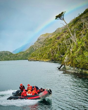
A bonsai shaped Lenga tree in a rainbow looming over our Zodiac as we return to our boat in the Patagonian fjords.
The Shot
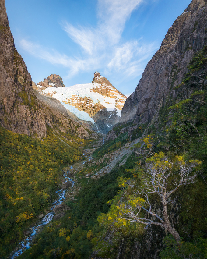
This is another image of the same area as the waterfall described in my June 7 Land of Giants Friday Photo. If you look closely, you can see the falls in the lower left.
After the falls image, I flew a second drone flight up the glacial stream and higher up. This time, I was looking to include a foreground Lenga tree.
The shape of Lenga in the lower right seemed to complement the diagonal of the stream leading to the glacier. And the trees were starting to turn color (April is fall in South America) adding a pop of yellow to the scene.
Thanks for looking,
Chuck Derus
Thank the Vikings

Fjord and sound. Both words evoke visions of valleys formed by soaring ice-covered peaks reflecting in deep blue, placid waters far below. They are magical places.
But is there a difference between a fjord and a sound? Thanks to the Vikings, the answer is yes.
Fjord comes from the Old Norse word fjǫrthr meaning “to travel across.” Sound stems from the Old Norse word sund meaning “swimming” or “strait.”
A fjord is an underwater valley carved by glaciers. U- and V-shaped valleys carved by ancient glaciers left steep-sided mountains on either side. After the glaciers retreated, sea levels rose by as much as 390 feet inundating the carved valleys with sea water.

The Patagonian Ice Sheet during the last Ice Age. From antarcticglaciers.org:
A sound is a long, wide inlet of the sea between two peninsulas or other landforms. They are usually wider than a fjord. These underwater valleys are formed by river valley flooding, not by glaciers. Sounds often parallel the coastline, separating it from an island.
Both are often mistakenly used interchangeably. Milford Sound in New Zealand is technically a fjord, and Limfjord in Denmark is actually a sound!
My Visit
The most exciting part of my April visit to Patagonia was experiencing the Chilean fjords. We departed from Puerto Natales and went into the Canal de las Montañas.

From Wikipedia.
Unexpectedly, the seemingly ever-present howling winds and overcast skies of the fjords gave way to a pair of sunny, calm days. We could fly our drones!
The Shot
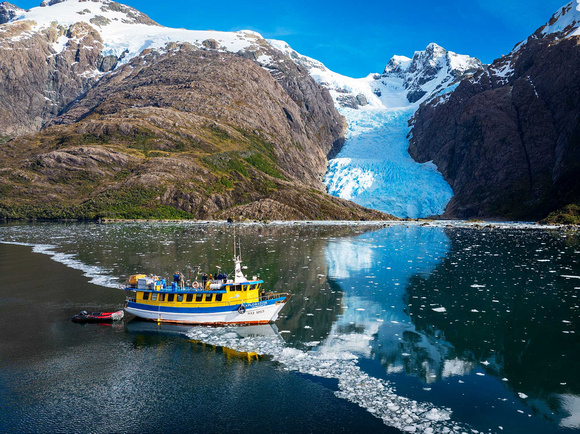
On April 15, we motored to the Bernal Glacier, a 30,000-year-old glacier slowly inching into the Canal de las Montañas. It was tricky flying because drones require line of sight to control them. Our foreground was on the very edge of our ability to maintain radio contact and control them.
The foreground was about three miles away at an altitude of 2,300 feet. Once I flew there, it was a matter of fine tuning the drone’s location. I wanted the glacial cracks aligned with the Cordillera Sarmiento Mountains about four miles further away.

The locations of the boat, Bernal Glacier, drone, and Cordillera Sarmiento Mountains.
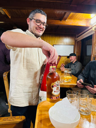
Later that evening, Pim, the ship’s cook, poured Chivas on the rocks after dinner. But it wasn’t ordinary ice; these were 30,000-year-old ice cubes from the glacier.
You never know what you’ll experience when you travel!
The next Friday Photo is July 12 due to a family vacation.
Thanks for looking,
Chuck Derus
Icy Wilderness
It’s the result of ice. Lots and lots of ice.
The million-acre Boundary Waters Canoe Area Wilderness (BWCAW) was formed by glaciers that scraped and gouged the rock of far northeastern Minnesota. The last Ice Age’s alternating episodes of glacial advance and retreat encompassed the period c. 115,000 – c. 11,700 years ago.
When it finally ended, their passage left behind rugged cliffs, crags, canyons, gentle hills, towering rock formations, rocky shores, sandy beaches and several thousand lakes, streams, and islands all surrounded by forest.
The BWCAW extends nearly 150 miles along the international boundary between Canada and the United States. North of the border is Canada’s Quetico Provincial Park while Voyageurs National Park is to the West in the U.S.
The BWCAW offers priceless solitude, challenge and absorption into nature. You won’t see motorized vehicles or many people on its more than 1,200 miles of canoe routes, 12 hiking trails, and over 2,000 designated campsites. You will see black bears, moose, foxes, and deer. And if you drop a line in the water, you’ll be rewarded with trout, walleye, bass, pike, muskie, and panfish.
The area was set aside in 1926 to preserve its primitive character. It became a part of the National Wilderness Preservation System in 1964 allowing visitors to canoe, portage and camp in the spirit of the French Voyageurs of 200 years ago.
My Visits
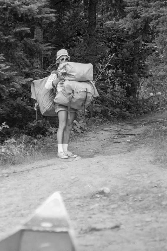
I’ve been fortunate to spend time in the BWCAW on several occasions. My first trip was during medical school. Eight of us from our Nu Sigma Nu medical fraternity set off during summer break.

That’s me on the far left.
Back then, we either portaged a double pack or a canoe and a single pack. On my last trip there thirty years ago with my son, I was down to a single pack or the canoe.
My medical school roommate Jeff Knutson shows off what a 25-year-old can portage.
Luckily, there’s always down time between canoeing and portaging. For some it’s a book. For others it is sitting down and enjoying the view. I always enjoyed the chance to fish.

Waiting for a bite (fish, not mosquito).
The Shot
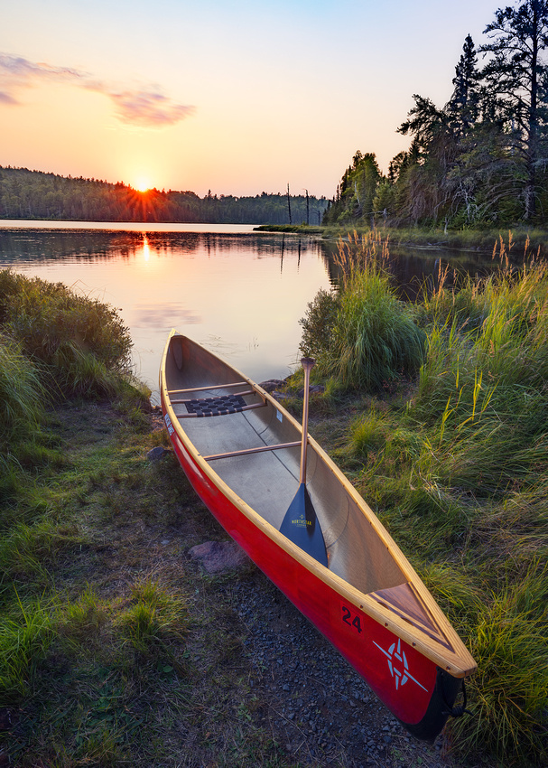
Last August I was with Jon Christofersen and several other photographers on a workshop photographing the Milky Way. We stayed in Grand Marais, Minnesota and drove north along the Gunflint Trail Road near the BWCAW every evening for photography.
I wish I could tell you that the red canoe just happened to be at Swamper Lake. But our group leader had brought it along as a prop with this type of image in mind. The scene brought back memories of past serene BWCAW evenings with friends and family.
Since the sky was nearly empty of clouds, I decided to wait for the sun to kiss the horizon. The resulting sun star helped add visual interest to the photo.
Thanks for looking,
Chuck Derus
"Udderly" Striking
No, it’s not a typo. This title is for my good friend and fellow punster since seventh grade, Mark Hendrickson.
Look at the prominent pouch-like clouds on the left underneath the anvil cloud. Those are mammatus.
Most clouds form in rising air. But not mammatus clouds. They are a rare example of upside-down clouds formed by sinking air.
Mammatus clouds require three ingredients. The first is that the sinking air must be cooler than the air around it. The second is that the sinking air has a high liquid water or ice content. The third is the presence of dry air beneath the moist air.
As the cooler, water/ice-rich air sinks, bag-like cloud sacs form that resemble cows’ udders. The name comes from the Latin mamma meaning udder. Although mammatus most frequently form on the underside of a cumulonimbus cloud, they can develop underneath cirrocumulus, altostratus, altocumulus, and stratocumulus.
Mammatus clouds last longer if the sinking air contains large water drops or large snow crystals. The larger the particle, the more energy and time it takes for evaporation to occur. But the cloud droplets eventually evaporate and the mammatus clouds dissipate.
Mammatus clouds are most often associated with anvil clouds and severe thunderstorms. While they look scary, they are not a warning sign of an impending tornado.
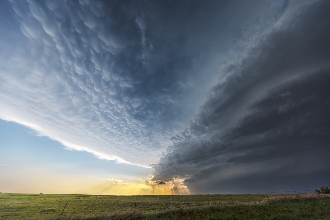
The Shot
On May 19, our storm chasing tour was positioned near Arnett, Oklahoma. The leader picked this supercell as having tornadic potential. But it was a high precipitation supercell that hid any tornadoes inside a torrential downpour.
During our several hour chase, we noticed crepuscular rays (sun beams or God rays) in the distance. We had to stop for photos because an interesting atmosphere is irresistible to photographers.
All we had for a foreground was a barbed wire fence. You’re probably thinking “Couldn’t Chuck find a more interesting foreground?” Please feel free to visit rural Oklahoma and discover a more interesting foreground for my next photo there. 😊
I was struck by the combination of beautiful mammatus above, sun beams in the distance, and the dichotomy between the ominous, dark supercell on the right and the sun peeking out on the left.
We all took a moment from our photography to simply admire the view. The quotation from Cheryl Strayed in her book Wild came to mind. “There’s always a sunrise and always a sunset and it’s up to you to choose to be there for it… Put yourself in the way of beauty.”
Thanks for looking,
Chuck Derus
In the Fjords

Travelers often perpetuate myths. In 1520, The explorer Magellan used the term Patagón (possibly meaning bigfoot) to describe “giants” living in the southern tip of South America. By his and other accounts, they exceeded at least double normal human height.
Early maps of the New World would sometimes attach the label Regio Gigantum (region of giants) to the area. It’s likely the native Tehuelche, who tended to be taller than Europeans of the time, were the origin of this myth. Tales of giants maintained a hold upon European imagination for nearly 300 years.
The name Patagonia (land of giants) for the region stuck. The region encompasses the southern end of South America.

Patagonia is shaded orange. From Wikipedia.
In the west, it encompasses the southern section of the Andes Mountains along with lakes, fjords, temperate rainforests, and glaciers. In the east, it contains deserts, tablelands, and steppes. With so many features, it’s a photographer’s paradise.
What’s a Fjord?
A fjord is a long, deep, narrow body of water that reaches far inland. Fjords are often set in U-shaped valleys with steep walls of rock on either side.
To be named a fjord, it must be created by glaciers. During the last ice age, glaciers covered just about everything. The movement of glaciers below sea level carved deep valleys. As the ice age ended, these valleys, sometimes thousands of feet deep, were filled with sea water creating fjords.
Fjords are found mainly in Chile’s Patagonia, Norway, New Zealand, Canada, Greenland, and Alaska. Their size can be mind boggling. Sognefjorden, a fjord in Norway, is almost 100 miles long.
The Shot
My trip to Patagonia in April included four days on a boat in the remote Patagonian fjords. We departed from Puerto Natales and were blessed with two days of mild weather, an unusual occurrence in this region.
Our vessel the Explorador
Our drones turned out to be extremely useful. While beautiful from a distance, the interesting features like glacial streams and waterfalls were inaccessible due to nearly impenetrable forest and grueling climbs.

That tiny stream in the valley looks photogenic but is impossible to reach by foot.
Thanks to my drone, I was able to fly upstream and identify several interesting compositions. After taking this image, I flew to an altitude of 3,000 feet and discovered a gorgeous alpine lake over a mile away.
Thanks for looking,
Chuck Derus