Welcome to the landscape photography blog by Chuck Derus. Thanks for looking and for your comments!
Immersed

Have you ever felt like you could walk into a painting or a photograph? And did you linger in rapt attention, eyes moving throughout the image? I experienced this recently.

Bill Hughes (1932-1992) Canyon Passage 1991 Oil on Canvas
I was in Marietta, Georga in June visiting friends John and Joann Vineyard. They suggested a visit to the nearby Booth Museum of Western Art. This painting stopped the three of us in our tracks. We felt compelled to “walk into it” and linger.
The 3-D Challenge
Grabbing and maintaining interest in a two-dimensional landscape image requires conveying a sense of depth. You need clues to spatial relationships.
Painters start with a blank canvas and add clues to convey depth. It’s a distinct advantage.
But photographers must choose complimentary subjects and then coherently arrange them in the field. And processing the image in Photoshop™ is often necessary to enhance a sense of depth.
It isn’t always possible. Sometimes photographers reluctantly move on from beautiful scenes because they didn’t convey depth.
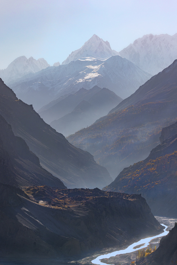
Atmosphere is an ally. The sense of three-dimensionality in last week’s Altit Fort photograph was due to atmosphere. The smoke separated the Fort from the distant mountainside creating a sense of distance.
Dust, fog, smoke, and clouds cause objects in the distance to become less distinct, lighter, and less saturated compared to foreground objects. Those clues to distance quickly attract photographers to the subject and viewers to their images.
The Shot
This was taken just after the Altit Fort photograph from last week’s Friday Photo. I had my telephoto lens attached looking for a way to use it to my advantage. A telephoto lens compresses perspective, making objects appear closer together.
After spotting the compressed repeating triangle shapes of the mountainsides retreating into the hazy distance, I knew I had my composition with those much-needed clues to depth.
Thanks for looking,
Chuck Derus
Altit Fort
The Hunza Valley is tucked away among the precipitous peaks of the Karakoram Mountains in northern Pakistan. Its natural splendor and position on the Central Asian Silk Road have attracted travelers, merchants, and trekkers for centuries.
Beyond its jagged peaks, glaciers, apricot farms, and turquoise lakes, the Hunza is also rich in cultural heritage. Such is the case with Altit Fort.
The People of the Hunza
The origins of the Burusho people in the Hunza realm remain a mystery. Interestingly, the local language has no known links to any other language. So, where did they come from?
According to legend, Altit village was once known as Hunukushal, which means “village of Huns.” Some claim to be descendants of Huns who arrived in the first century from the Huang-Ho valley in China. Others believe themselves to be descendants of Alexander the Great's Greek soldiers.
Over time, the name of the village changed to Broshal, which means “village of Burushaski speakers.” The people of the village used to follow Buddhism and Hinduism until they were introduced to Islam in the 15th century. In the 1830s, many of its inhabitants embraced the Ismaili sect of Islam.
The Tower and the Fort
The hereditary rulers of the Hunza state are titled Mir. One of them built the Shikari Tower (the first part of the Fort) 1100 years ago. Home to the Royals, the Tower monitored and defended caravans traveling on the Silk Road.
In the 16th century, the local prince married a princess from Baltistan who brought craftsmen to build Altit Fort and nearby Baltit Fort. Subsequently, the Mir and his family moved to Baltit Fort.
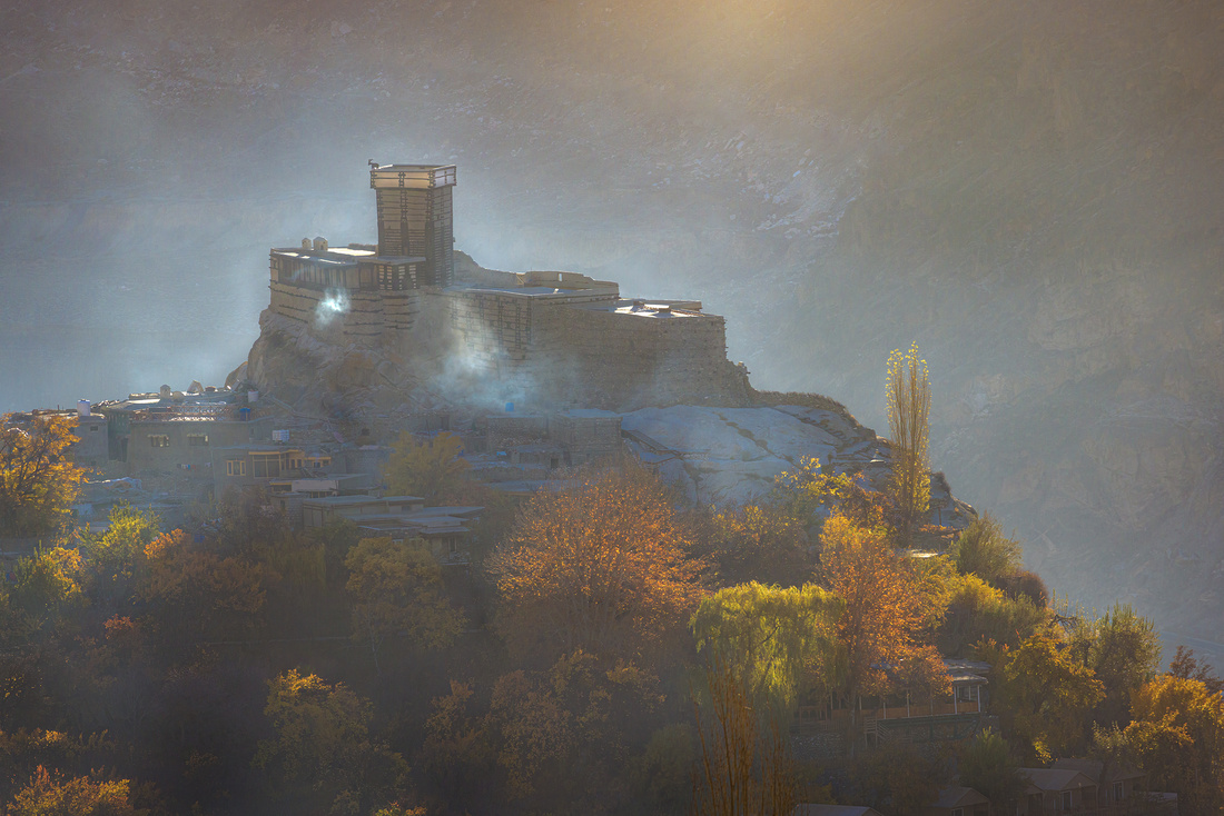
Located 1000 feet above the Hunza valley, Altit Fort has a commanding view of the area. The Fort survived centuries of enemy attacks and earthquakes. The builders truly deserve the term craftsmen. The Fort is so well built that it can survive an 8.5 magnitude earthquake!
It wasn’t until 1972 that Hunza transitioned from being a princely state to becoming formally part of Pakistan. Altit Fort is now a popular tourist destination after its restoration by the Aga Khan Foundation in 1990. The museum provides significant insights into the lives of the Mirs and the Royals that lived there.
The Shot
Structures normally don’t interest me. Landscape is my passion. But occasionally, something manmade captivates me.
We drove to a ridge overlooking the Fort last November 11th. Below us, the wonderous Altit Fort dominated the countryside. Wood smoke from thousands of breakfast cooking fires shrouded it in mysterious light.
I must thank photographer Atif Saeed and guide Muqeem Baig for sharing the Hunza with us. While the scenery was gorgeous, their friendship made it a special experience.

Thanks for looking,
Chuck Derus
What's Behind the Logo
What’s the story of this famous brand’s logo?

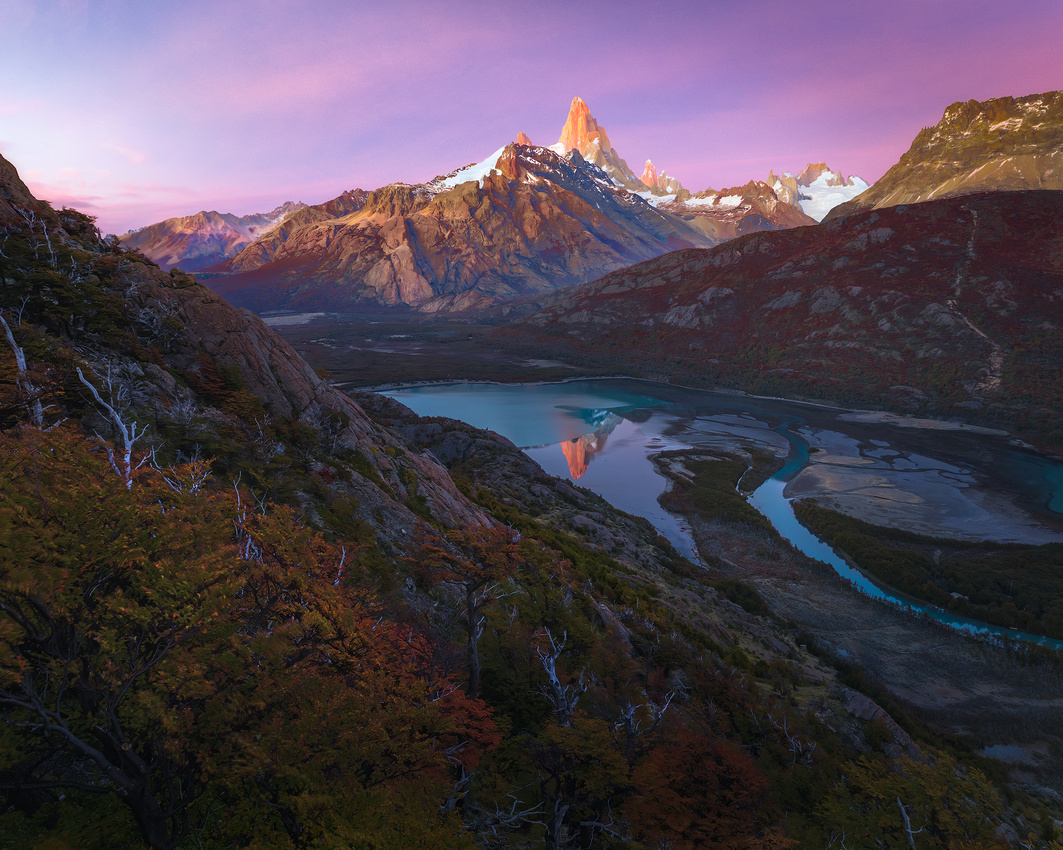
The Patagonia® logo is an Andes Mountains skyline at sunset. The iconic peak right of center is Mount Fitz Roy, located on the border between Argentina and Chile in the region of Patagonia.
The brand’s founder, Yvon Chouinard, began climbing as a fourteen-year-old in 1953. In 1957, he started forging his own chrome-molybdenum steel climbing pitons. They were an excellent product and soon he was in business.
In 1968, Chouinard climbed Fitz Roy. By then, he was concerned about the environmental impact of steel pitons fracturing rocks. He invented aluminum chocks that could be wedged by hand rather than being hammered in and out of cracks.
The first Chouinard Equipment catalog appeared in 1972. Sierra climber Doug Robinson promoted the chocks. Within a few months, Chouinard’s chocks replaced steel pitons.
His Patagonia® company and logo were officially launched in 1973. To support the marginally profitable chock business, his company expanded into clothing – and the rest is history.
The Man Behind the Mountain’s Name
Spanish explorer Antonio de Viedma was the first European to see the mountain in 1783. Argentine explorer Francisco Moreno later named it in honor of British Vice Admiral Robert FitzRoy.
FitzRoy was captain of HMS Beagle. The most famous voyage of the Beagle was its five-year second voyage from 1831 to 1836. His ship carried the recently graduated naturalist Charles Darwin around the world.

Vice Admiral FitzRoy from reddit.com
FitzRoy was also a pioneering meteorologist. He made accurate daily weather predictions and coined the term "forecasts."
In 1854 he established The Meteorological Office, the United Kingdom's national weather and climate service. To this day, the Office provides weather information to sailors, fishermen, and the public for their safety.
The Shot
Patagonia is famous for its winds. They seldom abate. Reflection images require calm conditions and are usually out of the question in Patagonia.
Imagine my surprise when I woke up last April 11. It was calm! Our group drove to a location just outside Los Glaciares National Park near El Chaltén and launched drones.
We were astounded to see a perfect reflection of Fitz Roy in the Río Cañadón de los Torres. We quickly captured images as we worried about a sudden return of the winds. But our luck prevailed, and we were able to fly for a full thirty-minute battery life.
I felt doubly blessed returning to our hotel for breakfast. On my first trip to Patagonia a decade ago, I also had the rare opportunity to capture this reflection image.

Thanks for looking,
Chuck Derus
Grupo La Paz

“A stunning place where glaciers fall from the peaks to the sea, turquoise lakes abound, and carnivorous plants guard the entrance to mysterious mountain valleys.” That’s how @patagoniavertical describes the Cordillera Riesco Mountain range
The Grupo La Paz rock towers are the centerpiece of the Riesco. Located in Chilean Patagonia to the west of Puerto Natales, they extend in a north–south direction on the eastern shore of the Fjord of the Mountains.
Aguja Oeste at 3,900 feet is the highest in Grupo La Paz. The tower was first climbed in 1988 by Yvon Chouinard and Jim Donini. One of our guides on the photography charter boat recently traversed the Grupo. Antar Machado was the expedition’s photographer.

Antar’s route traversing the Grupo La Paz. From REGION MAGALLANES - CORDILLERA RIESCO - Grupo... - Patagonia Vertical | Facebook
You can read about Antar’s expedition at https://publications.americanalpineclub.org/articles/13201216189.
Here’s Antar (on the left) looking at my friend Jon Christofersen’s drone composition on the deck of our ship.

The Shot
Often, landscape photography is a leisurely pursuit with cameras mounted on tripods waiting for just the right light to take a picture. Not so on a boat! As we cruised by various features, we had to be prepared to quickly capture an image.
That was the case as we cruised past Grupo La Paz on our April trip to Patagonia. Out of three passes, this pass by appealed to me the most because of the weather. Something about the sky and the light brought a smile to my face as we motored by.
After quickly attaching my telephoto lens, I took a variety of compositions at 200mm. After that, it was time to get out of the rain below deck and enjoy a hot cup of coffee.
Thanks for looking,
Chuck Derus
The Bear's Cage

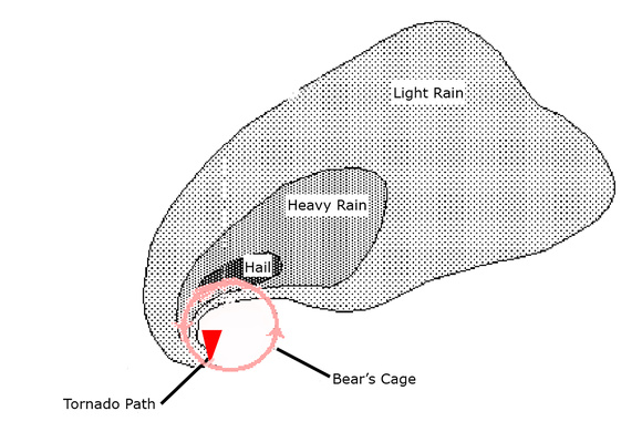
I’m not talking about visiting the zoo. The bear’s cage is a slang term used by tornado chasers. The bear is the danger of a tornado, and the cage is the area where it forms.
The cage is located beneath a rotating supercell wrapped in heavy precipitation (rain or hail). It often coincides with the characteristic radar hook-echo signature of potential tornadoes. Visibility in the cage is often poor, and the bear can appear without warning.
From www.flame.org
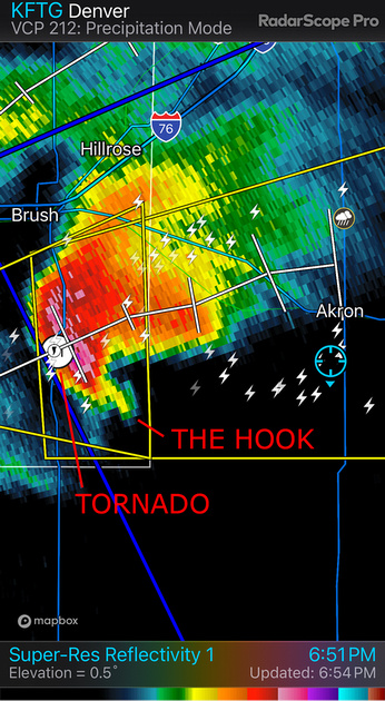
An example of a radar hook-echo signature and a tornado. I’m a safe distance away in the blue circled location.
May 21st
The National Weather Service predicted severe, dangerous storms in southwest Iowa. We drove there in the morning to be in position.
The prediction was spot on. By the early afternoon, intense storms started forming. Soon afterwards, intensifying low level winds added the last component needed to produce tornadoes. We ended up spotting four tornadoes.
Number one was near Red Oak, Iowa. It formed a nice stovepipe that lasted several minutes.
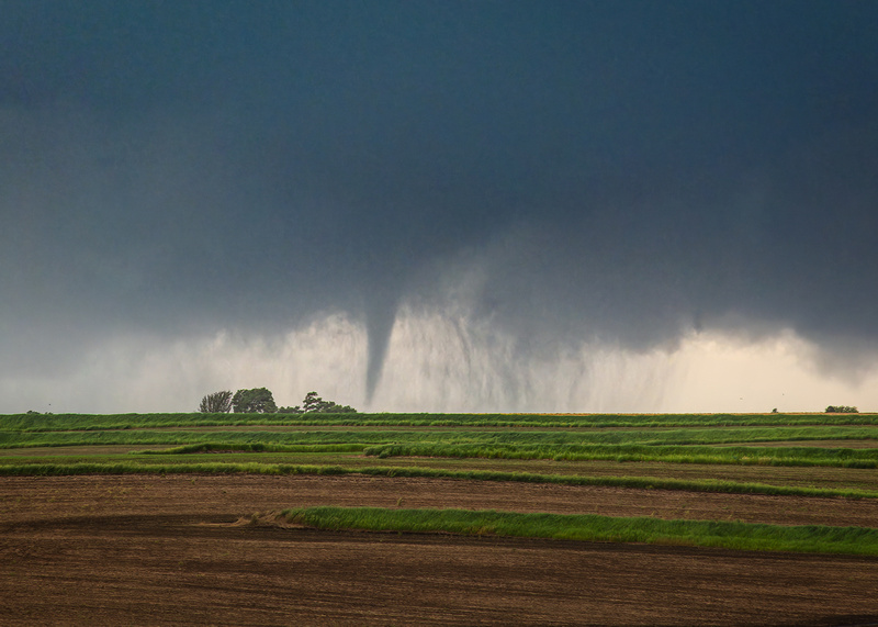
The Red Oak, Iowa tornado.
We moved to a new location to observe another supercell with tornadic potential. Since tornadoes move northeast, setting up south of the expected path is the safest place to be.
We didn’t have to wait long. A supercell approached our position at 60 mph. As it sped towards us, a big bowl-shaped tornado dropped that was wrapped in violently rotating curtains of rain.
The bear’s cage started hitting a tree line a little over a mile away when we realized we were uncomfortably close. We jumped into the van and drove away to the east at high speed.
Sitting in the rear seat, I turned around and saw the bear’s cage growing larger and closer. After what seemed an eternity (probably only 30 seconds), we pulled away to safety.
Jon Christofersen filmed a hyperlapse video of the tornado’s approach. You can view it at https://cderus.zenfolio.com/p476844829/h1bacd4b5#h1bacd4b5.
Tornado number three was a large, destructive multi-vortex tornado. We watched it roar across the road a mile or so east of us. It struck the communities of Villisca, Nodaway, Brooks, Corning, and Greenfield, killing 5 people and injuring 35 others.

An iPhone shot out the front window of the early phase of the deadly Greenfield tornado.
That tornado was rated as a high-end EF4 with ground wind speeds estimated at 185 mph. Wind speeds of 308–319 mph at 36–38 yards above the surface made it the third strongest winds ever recorded in a tornado.
The peak width was 1,600 yards. It stayed on the ground for nearly 43 miles during its 48-minute existence.
We briefly saw our last tornado, number four, as we drove north to get ahead of the storm. But a storm core with huge hail and blinding rain blocked us from continuing the chase. We called it a day.
It was an exhilarating, yet intensely sad day. A four-tornado day is remarkable. But lives were lost, people were injured, and homes and businesses were destroyed.
The Shot
This image of tornado number two was taken a few seconds before we bugged out. From now on, the only bear’s cage I want to see up close is at Brookfield Zoo.
Thanks for looking,
Chuck Derus